| Top Page | Mountains, Valleys & Waterfalls |
|
Mt. Shiraki (889m) |
|
|
|
|
Shiraki Town Asakita Ward, Hiroshima City | |
|
白木山 白木町 | |
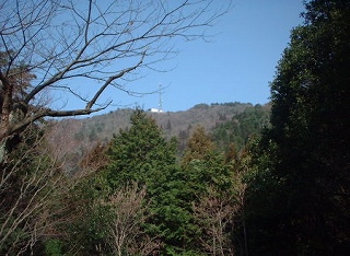
| Map | The summit of Mt. Shiraki is seen from the 8th level. |
|
The 889-meter-high Shiraki Mountain is the highest one in Hiroshima City, and stands
in Asakita Ward, 25 kilometers northeast from downtown Hiroshima.
At the foot of the mountain, 70 meters above sea level, is the JR Shiraki-yama station
on the Geibi Line, which was fondly named after this popular mountain. Mt. Shiraki is only half the height of the 1,712-meter Mt. Daisen in Tottori Pref., but there is not much difference in the actual climbing distance between the two mountains, because the foot of Mt. Daisen is already around 800 meters above sea level. Mt. Shiraki attracts many hikers all year round, especially for those who want to climb up higher mountains like Mt. Daisen or 3,000-meter class mountains in the Japan Alps. It will be a bit hard to ascend it for those who are not strong hikers, but it is worth conquering. The panoramic view of 360 degrees from the summit is breathtaking, if the weather is good. Getting there: Take a train on JR Geibi Line and get off at Shiraki-yama Station. From the station, cross the railroad tracks to the mountain, and walk up for about 10 minutes on the paved road. Then enter the well-preserved mountain trail. It is a 2.5-hour ascent to the mountain top. Suggested schedule: JR Hiroshima Station(7:52)==(Geibi Line)==Shirakiyama Sta.(8:40)--- ---Mt.Shiraki(11:30-13:00)---Shirakiyama Sta.(15:13)=== ===(Geibi Line)===Hiroshima Station(15:48) Note: To be safe, especially in winter, keep in mind not to go into the mountains alone, and be sure to go with a well-experienced hiker. |
|