| Top Page | Mountains, Valleys & Waterfalls |
|
Sandankyo Valley |
|

|
|
|
Togouchi, Akiota Town, Yamagata-gun | |
|
三段峡 戸河内 | |
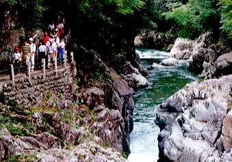
| Map | Hikers walk along the Shibaki River in Sandankyo Valley. |
|
Sandankyo Valley, designated as a national place of scenic beauty, is in the Western Chugoku Mountains Quasi-
National Park. The Shibaki River, a tributary to the Ota River (the mother of Hiroshima City), has flowed through
the mountain masses, eroding faulted valleys for hundreds of thousands of years to form the spectacular
12-kilometer Sandankyo Gorge. The altitude difference between Lake Hijiri, the uppermost reach of the river,
and the entrance of the gorge where former Sandankyo Terminal of the Kabe Line was situated, is about 400 meters. There are a number of soaring walls, rapids, and falls between them. The five wonders of the gorge are Mitsudaki Falls (quintupled-stepped falls), Sandandaki (triple-stepped falls), Sarutobi Rock (a narrow two meter-wide valley), Nidandaki Falls (double-stepped falls), and Kurobuchi (a deep pool with a soaring cliff), in that geographical descending order. There are three ways to access Sandankyo's scenic spots. * Take a 50-minute walk from Shibaki, the entrance of the gorge, passing through Kurobuchi Pool to Mizunashi-guchi. Sarutobi Rock is a 30-minute walk from Mizunashi-guchi, and a 5-minute boat ride to Nidandaki Falls. After returning to Sarutobi Rock by boat, then walk for another 30 minutes to Sandandaki Falls. * Drive directly to Mizunashi-guchi which is located halfway between Shibaki and Lake Hijiri. Or use a bus service (from April to November) bound for Mizunashi-guchi from Shibaki at 11:00 a.m. * Take an hour walk from Lake Hijiri, passing through Mitsudaki Falls to Sandandaki Falls. Getting there: * Take a bus from Hiroshima Bus Center to Sandankyo. * Go by car. Travel on the Chugoku Expressway, and get off at the Togouchi exit. Then take Route 191 to Sandankyo. Follow the signboard that reads " 三段峡” which means Sandankyo Valley. It will take about one hour from downtown Hiroshima. * To reach Mizunashi-guchi, drive further on Route 191 for 30 minutes. Soon after passing the entrance of Mt. Shinnyu (深入山), turn left onto Mizunashi Forest Road for 10 minutes. * Or you can drive further on Route 191 to Lake Hijiri for about 10 minutes after passing the entrance of Mizunashi Forest Road. Follow the signboard that reads " 聖湖” which means Lake Hijiri. Suggested schedule: Shibaki(The Entrance of Sandankyo Valley)(9:00)---Kurobuchi Pool--- ---Mizunashi-guchi(11:00)---Sarutobi Rock(11:30)===(boat)=== ===Nidandaki Falls(11:40-12:20)===(boat)===Sarutobi Rock--- ---Sandandaki Falls(13:00)----Mizunashi-guchi(14:00)===(bus)=== ===Shibaki(14:30) Note: To be safe, especially in winter, keep in mind not to go into the mountains alone, and be sure to go with a well-experienced hiker. |
|