| Top Page | Mountains, Valleys & Waterfalls |
|
Ryuzukyo Valley |
|

|
|
|
Tsutsuga, Aki-Ota Town, Yamagata-gun | |
|
龍頭峡 筒賀 | |
| Map | An area of Ryuzukyo Valley is designated as a Natural Environment Preservation Area by the prefecture. |
|
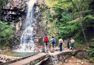
Ryuzukyo Valley is located off Route 186 10 kilometers toward Yoshiwa from the Togouchi exit of
the Chugoku Expressway. From the parking place of the valley a hiking course leads you to beautiful waterfalls including Nidan Taki (two stepped falls) with a drop of 40 meters. The hiking trail extends through a beautiful forest named Hikiake no Mori forest with 300-year-old trees such as cedar, fir and spruce trees. The round trip to the uppermost forest takes about three hours. On the first Sunday afternoon of October a Yabusame (horseback archery) festival is held in the 140-meter riding grounds of Hori Hachiman Shrine in Kake in Aki-Ota Town according to an ancient custom. It is said the traditional martial event dates back to 1439, and it was revived in 1991 after a long suspension. Riders who are clad in samurai (warrior) costume shoot arrows to three targets while riding a galloping horse. The thrilling performances are to be done three times during the event. Hori Hachiman Shrine is a two-kilomete drive on Rte.186 toward Kake from Togouchi. Click this link to see Yabusame event (Nihongo). Getting there: Go by car. Travel on the Chugoku Expressway, and get off at Togouchi exit. Then turn left on Route 186. Follow the signboards that read "龍頭峡” which means Ryuzukyo Valley. Suggested schedule: Hiroshima(8:30)==(Chugoku Expressway)==Togouchi exit(9:30)==(Rte.186)== ==Tsutsuga===Ryuzukyo parking place---Ryuzukyo Valley(10:00-11:30)--- ===Ryuzukyo parking place==((Rte.186)==Togouchi==((Rte.186)== ==Hori Hachiman Shrine (Yabusame festival site, 12:30-14:30)=== ===Togouchi IC==(Chugoku Expressway)==Hiroshima(16:00) Note: To be safe, especially in winter, keep in mind not to go into the mountains alone, and be sure to go with a well-experienced hiker. |
|