| Top Page | Mountains, Valleys & Waterfalls |
|
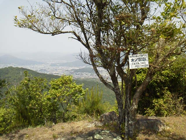
Mt. Kinomune (413m) |
|
|
|
|
Fukuda, Asakita Ward, Hiroshima City | |
|
木の宗山 福田町 | |
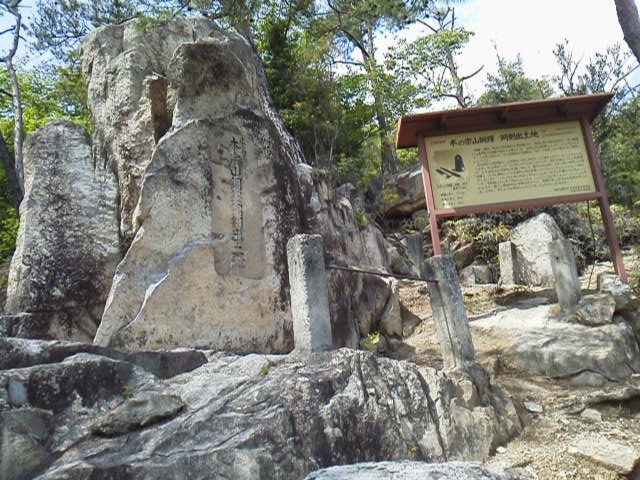
| Map | The Eboshi-iwa Rock, under which ancient bronzeware had been buried in the soil mixed with charcoal for a long period of time, is overlooking what was then Fukuda village. |
|
The 413-meter Mt. Kinomune is located in Fukuda, Asakita Ward, Hiroshima City.
The foot of the mountain is a park called Kinomune-yama Ikoi-no-mori (木の宗山憩の森)
which literally means Mt. Kinomune Relaxation Forest. It is situated on a pass connecting the Fukawa and Fukuda areas.
The five-meter-tall “Eboshi (nobleman’s headgear)-iwa Rock" sits on the 260-meter-high southwestern side of the mountain. Just around the rock is designated as a prefectural historic site. A set of ancient bronzeware, a 19-cm-tall bell, a 39-cm-long sword and a 29-cm-long halberd, was discovered under the rock in 1891 by local people. These date back to the latter half of the Yayoi period (the third or second century B.C. to the third century A.D.). It is said that they might have been used for a sort of ritual including praying for a rich rice harvest after Japanese had acquired the skill of rice cultivation during this period. A mountain trail starts from the pass, where a signboard has been put on the roadside that reads “ 木ノ宗山登山口”, which means the trailhead of Mt. Kinomune. Take a kilometer-long ascent to the mountaintop. Before reaching the top, at the second observation point, there is a signboard that reads “広島県史跡 銅鐸、銅剣出土地”, which means a prefectural historic site. Bronzeware excavation place. The ancient remains are located about 70 meters down from there. It will take an about 20-minute round trip to the place. From the top of the mountain, which was an old mountain castle site during the Warring States period (1467-1568), a good view of the city can be seen. Click this link to see a view of Central Hiroshima from the mountaintop. Getting there: From JR Naka-Fukawa Station on the Geibi Line, walk parallel to the train tracks for a hundred meters to a gas station, turn right toward Fukuda and walk for about three kilometers to Kinomune-yama Relaxation Forest. See the map. You can also go by car and park at the relaxation forest parking place. From downtown Hiroshima, take Route 54 to Ushita, then take Route 37 toward Koyo. After passing Naka-Fukawa post office, at the first traffic lights (a gas station is on the corner), turn right to Fukuda and drive for several minutes to the relaxation forest. Suggested schedule: JR Hiroshima Sta.(9:00)==(Geibi Line)==Naka-Fukawa Sta. (9:26)--- --- Kinomune-yama Relaxation Forest (10:15)---- ---Second observation point (10:40)---Prefectural historic remains--- ---Second observation point---(11:00)---Mt.Kinomune (11:20-12:20)--- --- Kinomune-yama Relaxation Forest (13:00)--- Naka-Fukawa Sta. (13:57)--- --- Hiroshima Sta.(13:39) Note: To be safe, especially in winter, keep in mind not to go into the mountains alone, and be sure to go with a well-experienced hiker. |
|