| Top Page | Mountains, Valleys & Waterfalls |
|
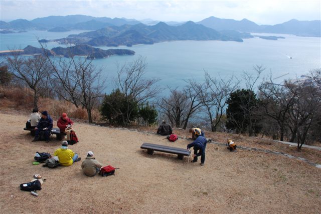
Mt. Fudekage (314m) |
|
|
|
|
Sunami Town Mihara City | |
|
筆影山 須波町 | |
| Map | A view from the top of Mt. Fudekage which is a part of the Seto Inland National Park and lies close to the neighboring 445-meter Mt. Ryuo. |
|
Mihara City was a castle town. Takakage Kobayakawa, the third son of a great war lord, Motonari Mori (1497-1571),
built a castle in 1567 at the mouth of the Nuta River. The 900-meter long, 700-meter wide ground of the castle
was made by connecting small and large islands with stone bridges.
He wanted to control the Inland Sea which was a busy trading route even then.
Local people still fondly call it “Uki-shiro” (floating castle), because it looked like that when high tides
occurred. A synthetic silk thread manufacturer, Teijin, made a factory here in1933, and afterwards so did a heavy industry maker, Mitsubishi. Since then Mihara has grown into an industrial city. From JR Mihara Station, walk west 200 meters and enter Teijin Street. Go south two kilometers down to the Nuta River and walk west 300 meters along the river and cross Nuta Ohashi Bridge to Wada-guchi busstop. Cross Rte.185 to the trailhead of Mt. Fudekage. From there take a 3.6-kilometer course including a paved road up the 314-meter mountain. It commands a fine view of many studded islands spread out as far as Shikoku. To go down take a different 3.5-kilometer course on a paved road to JR Sunami Station of the Kure Line. Getting there: Take a train on the Sanyo Line at Hiroshima Station, and get off at Mihara Station. Suggested schedule: Hiroshima Sta. (8:45)==(Sanyo Line)==Mihara Sta.(10:00)---Teijin Street--- ---Wada-guchi (10:30)---Mt. Fudekage (12:00-13:00)--- ---Sunami Sta. (14:30)==(Kure Line)==Mihara Sta. (14:37-15:18)== ==(Sanyo Line)==Hiroshima Sta. (16:33) *Train timetable may be subject to change. Note: To be safe, especially in winter, keep in mind not to go into the mountains alone, and be sure to go with a well-experienced hiker. |
|