| Top Page | Mountains, Valleys & Waterfalls |
|
Mt. Asahi (454m) |
|
|
|
|
Shimono Town Takehara City | |
|
朝日山 下野町 | |
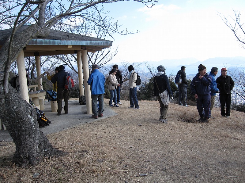
| Map | The top of Mt. Asahi is well maintained as a park. |
|
Mt. Asahi is situated in Takehara City, which is 70 km east from Hiroshima City. Takehara, whose name comes from its abundant bamboo forests, is an old salt town. In the mid-17th century, local people tried to reclaim the tidal land at the mouth of the Kamogawa River for farming, but failed. The salt-rich land was not fit for it. A merchant from Ako (now Hyogo Pref.) suggested transforming the land to a salt farm. People in Takehara invited experts in salt production from Ako, and began producing salt successfully in 1650. After that time Takehara had been prosperous as a salt town for 320 years. From JR Takehara station walk north for 25 minutes to Takehara Middle School. There is a water purification plant in front of the school. Just past the plant turn left and walk up to a farmhouse and enter the trail to Mt. Asahi passing by a storehouse. The trail is a bit steep and you have to walk on rubble, but it is worth climbing. It will take 1.5 hours to the mountaintop from where a breathtaking view of the Inland Sea with many dotted islands can be seen. Take the same trail down to the school, and walk east for 20 minutes to an area named "Special district for preservation of important traditional buildings". Many old houses of merchants, scholars and so forth, which will take you back a couple hundred years, are still remaining. Getting there: * You can take a train on the Kure Line at Hiroshima Station at 7:38 and change to another train at Hiro Station, and get off at Takehara Station. One-way ticket will be 1,140 yen. It will take about two hours. * You can also take a highway bus bound for Takehara Ferry from No.5 gate at Hiroshima Bus center at 9:00 a.m. or No.12 bus stop at C platform in front of the south side of Hiroshima Station at 9:14 a.m, and the one-way fare will be 1,290 yen and 1,180 yen, respectively. It will take one hour and 20 minutes. A prepaid IC card, Paspy, is convenient. It can be used for travel on most buses in Hiroshima Prefecture. It can be recharged. You don’t have to buy a ticket. Touch the card reader with it as you get on and as you get off the bus. Your fare, which is discounted 10%, is automatically deducted. * In case of going by car, you can park at a parking lot at Takehara City Hall near Takehara Station if it is not full. It will take about an hour from central Hiroshima if you take Sanyo Expressway to Kochi IC. Suggested schedule: Hiroshima Station(7:38)==(Kure Line)==Hiro Station==Takehara Sta.(9:39)--- ---Takehara Middle School(10:30)---Mt. Asahi(12:00-13:00)--- ---Takehara Middle School(14:00)---Special District for Preservation(14:30-16:00)--- ---Takehara Sta.(16:24)==(Kure Line)==Hiro Station==Hiroshima Station(18:21) *Train and bus timetables and fares may be subject to change. Note: To be safe, especially in winter, keep in mind not to go into the mountains alone, and be sure to go with a well-experienced hiker. |
|